Information about the Terra device

Hi, I’ve been using the TwoNav app on my phone for a long time and have been very happy with it. As for a dedicated GPS device, I’ve always used Garmin, but lately, I haven't been satisfied with their products (lots of bugs). I’m interested in the TwoNav Terra, but I have a couple of questions:
1) The latest Garmin GPS units feature dual-band technology for reception. Am I right in thinking the Terra doesn't use this technology? Does it still provide an accurate signal, even in dense vegetation?
2) On my Garmin, I used a lot of national maps—converted to JNX or RMAP formats (OSM, IGM, regional maps, etc.). Can I add these custom maps I’ve created to the Terra? Is there a maximum file size? Is RMAP the only supported format?
Thanks
-

Hello
For the first question:
La réception GPS multibande à pour objet d'éliminer la reception dite multitrajets, donc d'améliorer la précision de la localisation en ville (rues bordées d'immembles), en fond de vallée (ricochets du signal reçu sur les parroies rocheuses) et effectivement sous une canopée dense. Le terra n'est pas dité de cette technologie. Cela dit ça ne change pas la face du monde, il est possible que la trace puisse dans certains cas être décalée (la ou l'antenne recoit un signal réflechit), sinon Mr GNNS ne se serait pas casser la tête a inventer la reception multibande. Mais pour que ce soit efficace il faut aussi que les satellites aient cette capacité , or il me semble que c'est presque bon pour la constellation GPS, mais pas encore disponible pour Galliléo, pour les autres ce n'est pas à l'ordre du jour. Donc il faut un recepteur GNSS qui recoit les satellites GPS et que tous les satellites poursuivi par le recepteur soit pourvus eux aussi de la capacité multibande.
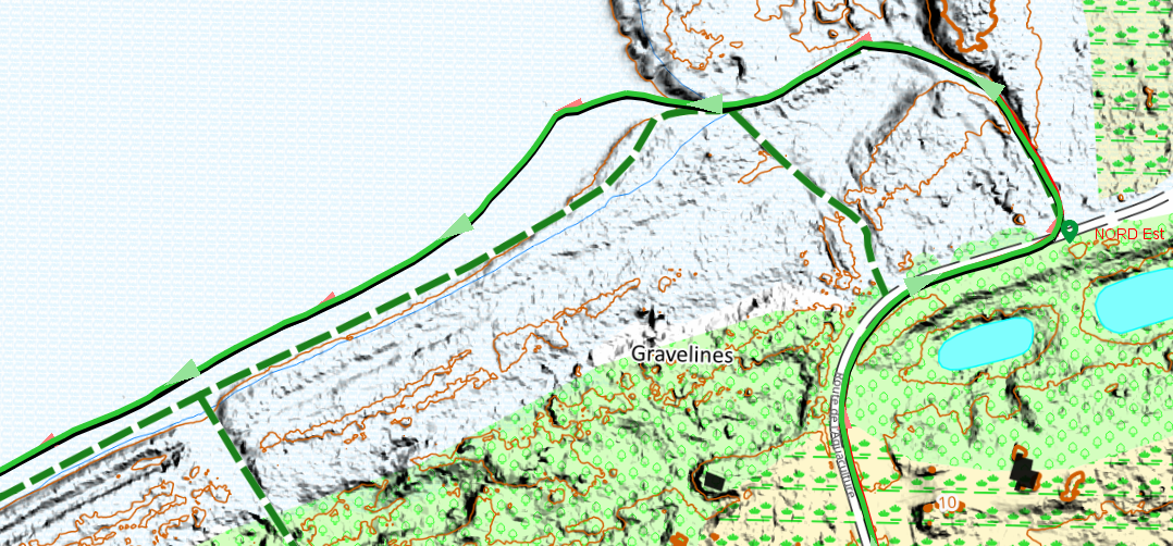
Clear skies near the sea; a multi-band trace and Terra overlap.
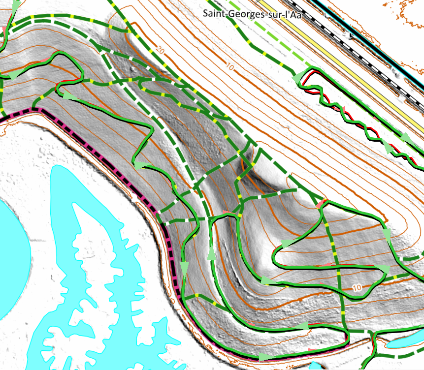
On a hill in the fog, the two tracks merge.
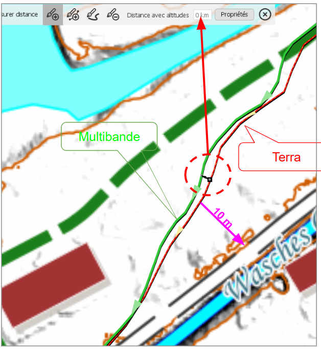
In the fog beneath a dense, low canopy. The 10 m reference indicates the magnitude of the error.
-
For the second question:
TwoNav's native formats are `.rmap` or `.rtmap` (and recently `.mbtiles`) for raster maps, and `.vmap` or `.mvp` for vector maps.
I use only open-source maps. For vector maps, I import data in `.osm` format, which Land then converts into `.vmap` (using a built-in tool) or `.mvp`. The source is the same as for Garmin (BBBike.de), but the export format is different (OSM). For raster maps, I use either MOBAC (exporting to `.rmap` or `.mbtiles`) or QGIS (open-source, exporting to `.mbtiles`).
You can also create maps from image formats (TIFF, JPEG, PNG), whether georeferenced or not (using the image calibration tool built into Land).
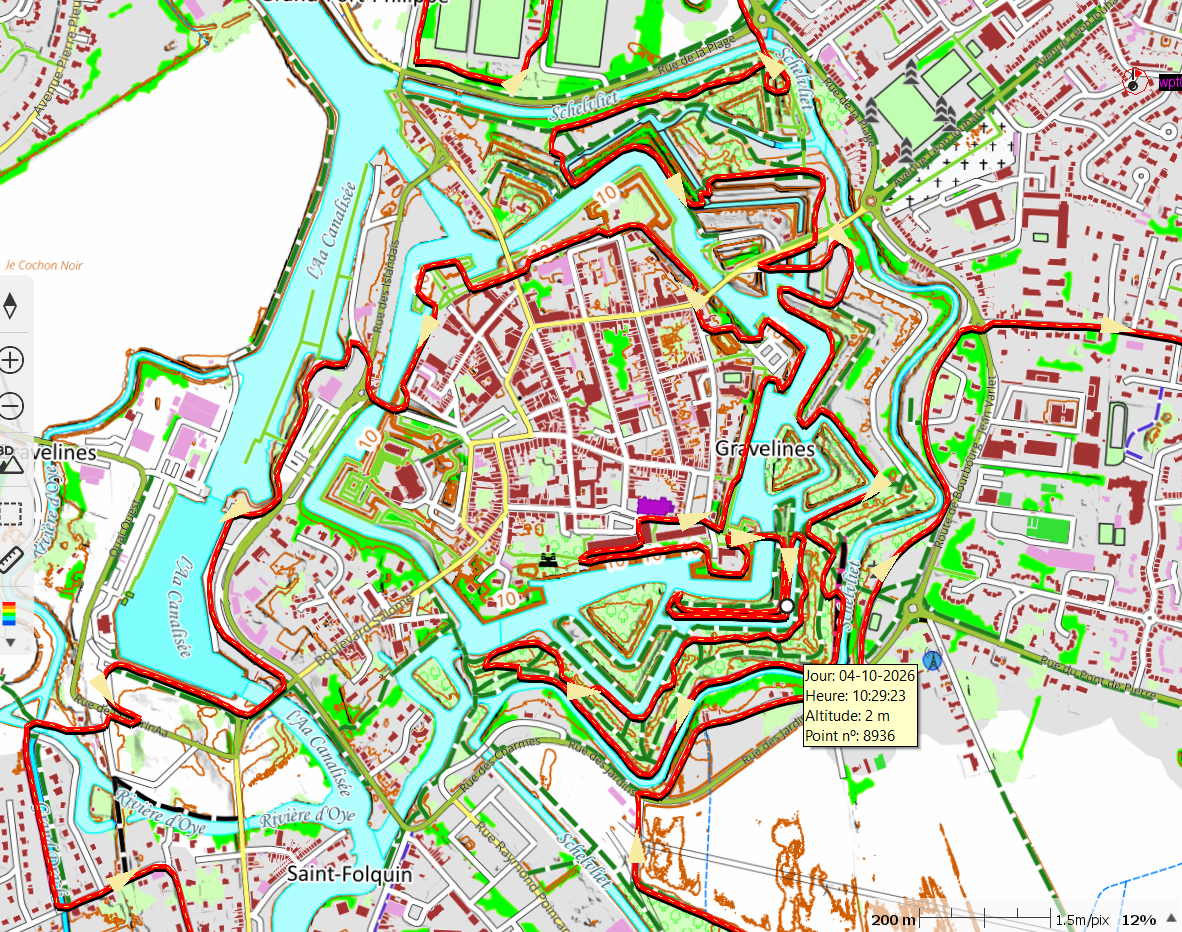
This is a custom raster map in MBTiles format (max zoom level 18); it is entirely open-source. Horizontal data comes from the National Geographic Institute (open source), vertical data is derived from the National Geographic Institute (0.5m LiDAR source), and roads, tracks, and trails were imported from OSM.
-
Thanks Thierry, very kind.
Looking at the maps on my old Garmin: I created some using Mobac and exported them in JNX format (though if I recall correctly, I could also export them as RMAP, so I imagine I could use those on the Terra as well). For other maps, however, I had to use Global Mapper—again exporting to JNX (and I don't remember if that program allowed exporting to a TwoNav-compatible format). Then, of course, I also have three maps in IMG format (OSM, Garmin Trek), but of those, the only ones I’d really want on the Terra are the OSM maps (specifically the ones I loaded myself), and if I’m not mistaken, that should be possible.
-
Hello,
One more thing—I almost forgot: Garmin devices have numerous size limitations, such as maximum numbers of waypoints, route points, maps, and so on. With TwoNav, you face no such limits; a single route file can include thousands of points. While Garmin integrates elevation data into routable maps, TwoNav uses independent files, which simplifies usage and allows for greater precision. The only real constraint is memory capacity—which has recently been increased to 64 GB, providing plenty of headroom. The Terra’s screen remains legible and bright, regardless of whether it is in direct sunlight or shade.
Best regards
-

Sorry to burst your bubble but you can't use Garmin vectormaps on the device. Vectormaps have to be created by yourself only in mpv or mpvf/vmap format (recent version of Land fail doing it in mpvf format which is more compact and ressorce friendly then mpv format - V896 was the last version which is doing this acceptable) or buy them from Compe (OSM database of some countries was recently fresh updated).
Creating maps in Land requires pro subscription, which is actually quite expensive compared to previous versions.
-
Thanks Charles for the input. I hadn't actually checked my 'ready-to-use' maps; I already had them all in .rmap format (I used to use them with the TwoNav app on my phone). The only ones not in that format are the 'img' maps (OSM, Garmin), but that shouldn't be a problem. I used an 8GB card with my Garmin and didn't have any issues (my maps take up a maximum of 6GB).
For Uwe, thanks for the clarification. I should mention upfront that I won't want to use Garmin vector maps on the Terra. However, I *will* want to use OSM vector maps. So, it won't be possible to have OSM maps on the Terra? (I used to load the well-known openMTB maps onto my Garmin.)
-
Hello,
OpenMTB Map is a map designed for Garmin devices; the data comes from OSM, and OpenMTB adds a specific rendering (visual style).
In principle, any user can do the same thing: import OSM data and apply a specific visual style. Sites like BBBike.de and Geofabrik.de offer this import capability. You can find all the information regarding OSM data imports on the BBBike website.
TwoNav includes an OSM map (e.g., *CountryName*26Q6OSM) with its GPS units; once loaded, this map has a standard (generic) visual style suitable for general use. In the properties section, you can customize the visual style to suit your needs—making it identical or very similar to OpenMTB, for instance. Personally, I use a visual style that closely resembles the IOF standard (MTB orienteering map).
You can apply this same style to your own OSM imports. As with Garmin, this involves a small associated file (*.clay); you create it by saving the properties of an optimized map, then simply duplicating it and giving it the same filename as the map itself.
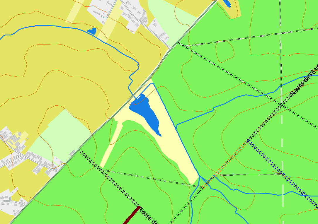
This is OSM Map with my personal customisation.
Yellow if the user see the Sky, Green under trees. For track and path the colors for the facility to ride (As defined by OSM data). I used two dotted lines, because a gpx track put au mask on the track or path draw on the map, with this issue the track loaded is located between the two lines, I can see le tracé GPX and highway classification facility to ride
You can also import OSM data into QGIS and export it as an MBTiles file using your own custom visual style.
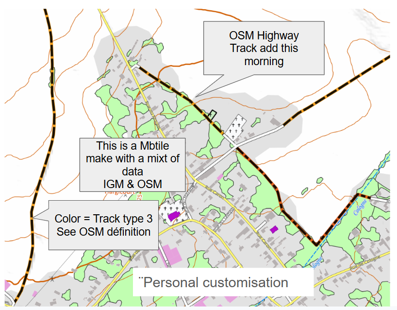
Here’s an example: this morning, while planning a future ride, I noticed two trails missing from the OSM map (the data wasn't there). I added these trails using the JOSM application (using aerial imagery and LiDAR terrain data as sources). By early afternoon, I had imported the OSM highway data to add as a layer to my map (simply replacing one layer), and my GPS map was up to date.
With open-source data, anything is possible now.
Exemple a raster Map from open source data, All data are defined in OSM (Open Mtb reda the OSM datas & add the visual look).
TwoNav GPS units do not feature automatic route calculation (something I call "Russian roulette," since you never know which way you'll end up going). Route calculation can be performed in Land, the TwoNav app, or on the GPS itself using the PaysOSM26Qx map before setting out on a hike. The "Fast Track" tool allows you to create a route with or without guidance.
-

"TwoNav GPS units do not feature automatic route calculation" > thats not true.
All the twonav devices that i have or have owned, beginning with Sportiva, are able to do a automatic route calculation for a point2point route. This can be done with every vmap, mpvf map which has the capability for it. If you can use fast-track, you can also use autorouting.
But don't expect to much from it. I mainly use it in unknown areas to find shortest way to a train or bus station.
Since first release of this functionallity more than 10 years ago, competeam doesn't developed it further.
Please sign in to leave a comment.
Comments
10 comments