problemas con mapas osm

Comentarios

41 comentarios

  • Avatar
    Thierry CHARLÈS

    Regarding mapping, in just a few years, almost everything has become accessible as open source for nearly all European countries. This process is underway, or at least there's the option of using OSM data. It's even possible to combine official geographic data and OSM data depending on the user's needs.

    Once you've mastered the tool, it's really fast, and you can design a map tailored to your specific requirements.

    The difficult part is getting started and finding the style files (object appearances). I suppose this is due to the redistribution organizations, since that's their core business.

    0
    Acciones de comentarios Permalink
  • Avatar
    Vito jack

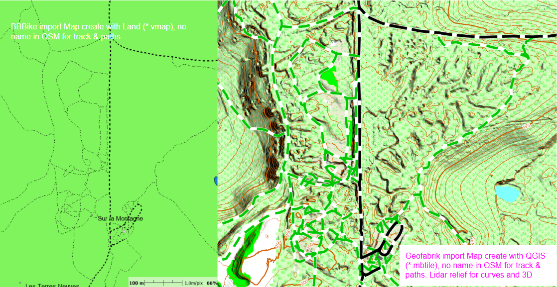
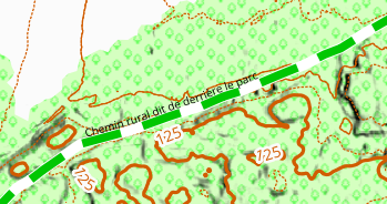
    But really, the big problem i’m dealing with, is to show the name of paths, tracks, trails, routes, etc. I explain:

    If i use the last 15Q2 map available of my region (Spain), it show the name of those different paths.

    But, if I “compile” a map direct from Geofabrik to Land, It does not show the name of most trails. Why? And how to correct this?

    0
    Acciones de comentarios Permalink
  • Avatar
    Thierry CHARLÈS


    Atterrir

    Tri personnalisé QGIS par type ; il est possible d'afficher un ou plusieurs points de données.

    La carte issue de la personnalisation ci-dessus

    0
    Acciones de comentarios Permalink
  • Avatar
    Thierry CHARLÈS

    Now Almost anything is possible

    0
    Acciones de comentarios Permalink
  • Avatar
    Thierry CHARLÈS


    But, if I “compile” a map direct from Geofabrik to Land, It does not show the name of most trails. Why? And how to correct this?


    0
    Acciones de comentarios Permalink
  • Avatar
    Thierry CHARLÈS

    Map setting you must tag all properties and save this data in a *.clay file.

    This file take the same name as the map, for an oter map cpy/past the clay file with the same name as the map layers


    0
    Acciones de comentarios Permalink
  • Avatar
    Thierry CHARLÈS

    0
    Acciones de comentarios Permalink
  • Avatar
    Thierry CHARLÈS

    For both maps, the visual aspect (Land is the *.clay file, QGis is the Qml file) is a personal setting.

    Same area

    0
    Acciones de comentarios Permalink
  • Avatar
    Thierry CHARLÈS

    If a name is provided by OSM 

    0
    Acciones de comentarios Permalink
  • Avatar
    Thierry CHARLÈS

    Among the series of tests I performed, one involved a raster map obtained via QGIS and, on top of it, the OSM *Vmap layer, for a scale management test.

    Screenshot at 72 dpi, GPS screen at 300 dpi, therefore four times better.


    0
    Acciones de comentarios Permalink
  • Avatar
    Vito jack

    I don’t understand the last reply.

    Why don’t show the name in Land, if the track have a name? Really, this is the problem i am trying to resolve…

    0
    Acciones de comentarios Permalink

Iniciar sesión para dejar un comentario.